 For Everyone
OSM Map on Garmin: The Complete Setup Guide
by AIR.POG Team
You're standing beside the vehicle with a Garmin connected by USB, a freshly downloaded map file on your computer, and no clear idea whether it belongs in Garmin, Map, or somewhere else. The file may even look correct, yet the device can still boot without showing it. With an OSM map on Garmin, the difficult part usually isn't finding map data. It's choosing the right build, preserving the expected filename, placing it in the correct directory, and deciding how often you're prepared to replace it.
OpenStreetMap gives Garmin owners a practical alternative to relying solely on the device's native map ecosystem. It also introduces a workflow that rewards careful file handling. Once that workflow becomes routine, sideloading stops feeling like a gamble and becomes a repeatable part of preparing for a trip.
Table of Contents
- Why Sideloading OpenStreetMap Transforms Your Garmin
- Sourcing and Downloading Pre-Compiled Garmin Maps
- Transferring and Installing the Map Image via USB
- Understanding the Map Compilation Pipeline
- Managing Map Freshness and Update Cadence
- Troubleshooting Boot Errors and Real-World Navigation Tips
<a id="why-sideloading-openstreetmap-transforms-your-garmin"></a>
Why Sideloading OpenStreetMap Transforms Your Garmin
A Garmin can feel perfectly dependable until a new bypass road sends you toward an old junction, a rural track is missing, or a trailhead appears nowhere in the installed map. Proprietary coverage can still be useful, but it puts the user inside Garmin's update and regional coverage model. OpenStreetMap changes the relationship. You choose the region, the map style, and often the provider that builds the Garmin-compatible file.
That matters most outside familiar roads. Cyclists may need minor lanes and mapped paths, while overlanders often care about remote access roads, service tracks, and small settlements. OSM data is community maintained, so its strengths and weaknesses vary by region. In places with active contributors, local detail can be excellent. In other areas, a commercial map may remain more consistent.
The appeal isn't limited to avoiding a purchase. A downloadable Garmin image can provide offline regional routing, which is valuable when mobile coverage disappears or international data costs make constant phone navigation inconvenient. Some providers also separate routable road maps from contour or topographic layers, letting you install only the information your device and trip require.
Field rule: Treat OSM as a map ecosystem, not a single file. The provider, region, map type, update date, and Garmin model all affect the result.
Garmin itself documents OpenStreetMap use across many products that feature mapping in its official OSM support guidance. The OpenStreetMap documentation says compatible uploads span device families including eTrex, GPSMAP, Nüvi, Zūmo, Oregon, Quest, and StreetPilot, provided the device supports map uploads, as described on the Garmin OSM map documentation. That's broad cross-line compatibility, but it isn't a guarantee for every model or firmware version.
The trade-off is control. Garmin's own tools usually understand their installed products automatically. OSM sideloading expects you to understand a file path and, often, a filename. For trip preparation, that small amount of responsibility is worthwhile. A useful starting point is this map planning resource, especially when you're deciding which areas deserve detailed preparation before departure.
<a id="sourcing-and-downloading-pre-compiled-garmin-maps"></a>
Sourcing and Downloading Pre-Compiled Garmin Maps
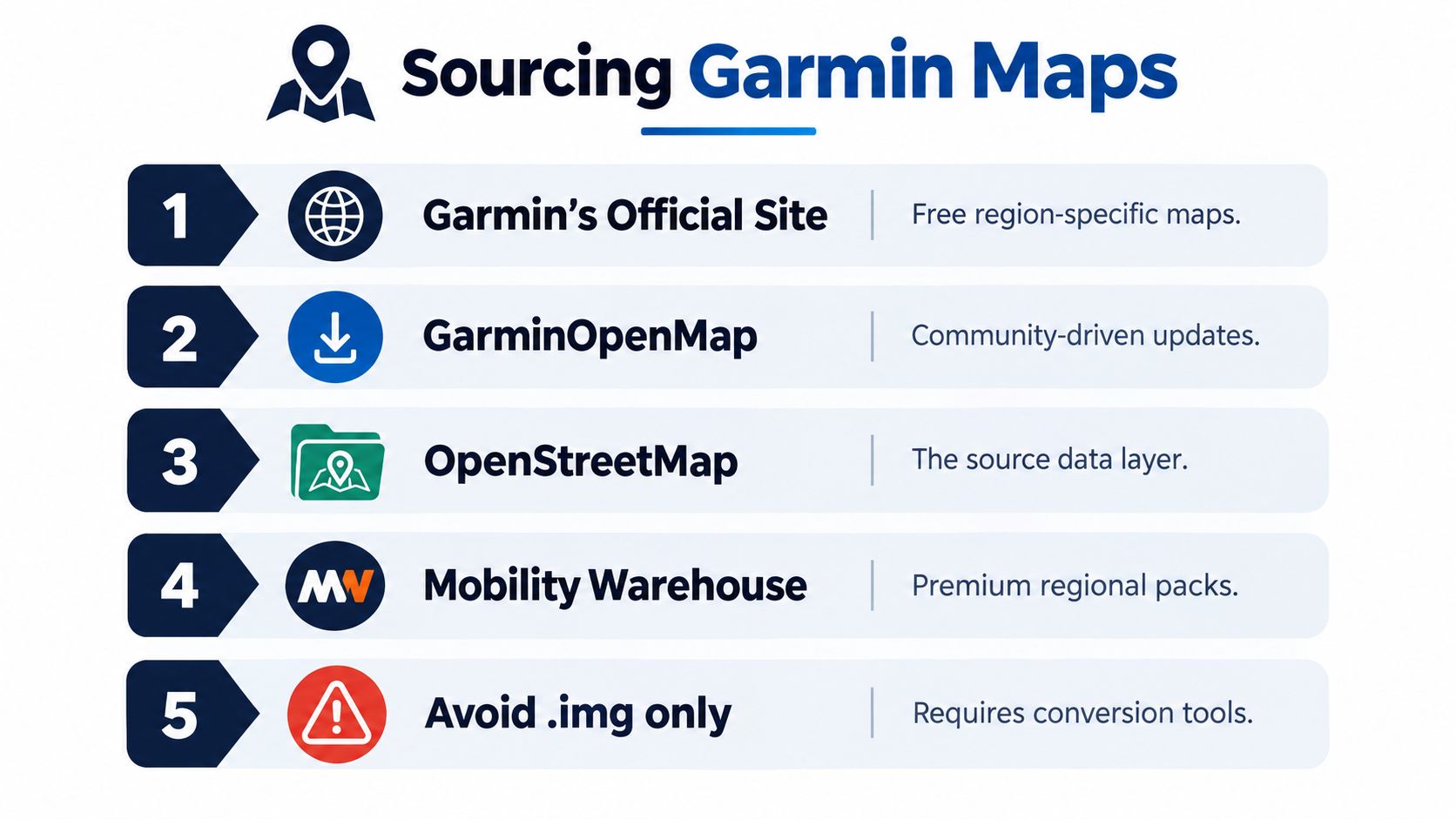
Start with a pre-compiled Garmin map unless you have a clear reason to build one yourself. A ready-made Garmin image has already passed through the conversion process, so your job is to select the correct area, confirm the map type, inspect the update information, and install the file without altering its structure.
The OpenStreetMap Garmin download ecosystem includes regional and country packages, and its index can filter for maps updated within the last 6 months according to the download index. That filter is useful, but freshness alone doesn't tell you whether a package is routable, topographic, or suitable for your particular Garmin.
<a id="match-the-build-to-the-trip"></a>
Match the build to the trip
Choose the map category before you download:
- Routable road map: Select this for turn-by-turn driving or cycling navigation. It needs routing data, not just visible lines.
- Topographic layer: Use this when elevation context, terrain, or trail visibility matters. It may not provide the same routing behavior as a road build.
- Regional extract: Prefer a focused area when storage is limited or the trip stays within a few neighboring regions.
- National package: Choose this for a long journey crossing a country, provided the device can handle the resulting file and map detail.
- Contour supplement: Treat contours as a separate layer when the provider offers them independently. Don't assume every road image includes terrain information.
The OpenStreetMap wiki lists mature country-specific distribution, including daily updates for Australia and an Italy package listed at 2,238.19 MB in the referenced documentation on the maintained Garmin map page. Those examples show why package selection matters. A nationwide image can be useful, but it can also consume substantial storage and take longer to transfer or process.
<a id="check-the-package-before-touching-the-garmin"></a>
Check the package before touching the Garmin
Read the provider's notes for the target device. Look for the supported Garmin families, whether the image is routable, the update date, the installation filename, and whether the download contains one compiled image or multiple parts. If the archive includes several .img files, don't copy them blindly. Some devices expect one combined gmapsupp.img, and the parts may need to be merged first.
A simple decision works well:
| Your trip | Sensible starting point | |---|---| | Local commute or weekend ride | Fresh regional routable build | | Remote cycling or hiking | Routable map plus a suitable topographic or contour layer | | Cross-country drive | Country package, after checking storage and device behavior | | Occasional offline backup | Stable regional image with a clearly recorded update date |
Keep the original archive until the Garmin displays the map correctly. Rename your computer copy with the region and date for your own records, but preserve the required device filename when you prepare the installation copy. That distinction prevents a common mistake, changing the filename on the device because it looks more descriptive.
<a id="transferring-and-installing-the-map-image-via-usb"></a>
Transferring and Installing the Map Image via USB
The installation itself is usually simple. The failure points are not. Garmin-compatible OSM maps commonly arrive as a compiled .img image, and direct installation typically means copying a single file into the correct Garmin directory through USB mass storage.
Before connecting the device, charge it enough to avoid an interrupted transfer. If you're using an SD card, insert it into the computer with a reliable reader and confirm that the card contains the expected Garmin folder. Keep a backup of existing files before replacing anything.
<a id="use-the-exact-path"></a>
Use the exact path
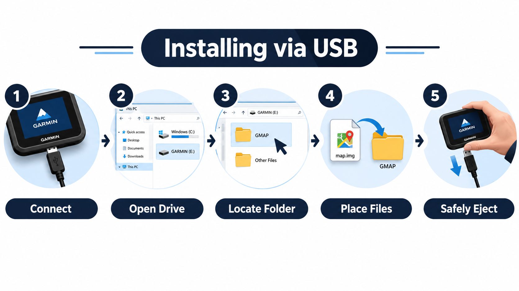
Connect the Garmin and select USB mass-storage mode if the device offers a connection choice. Open the device drive and inspect the root level. You're looking for a folder named Garmin. On some workflows, the map may be placed in a Map folder, but the required location depends on the device and build instructions. Follow the package documentation rather than guessing.
For the conventional direct workflow:
- Unpack the download on your computer. Don't copy an archive file to the Garmin and expect the device to extract it.
- Identify the compiled image. It should be an
.imgfile, not raw.osm,.pbf, or.xmldata. - Rename the installation copy to
gmapsupp.imgif the provider requires that convention. This exact spelling matters. - Open the correct
Garminfolder on the device or SD card. - Copy the file, then wait for the transfer to finish before disconnecting.
- Safely eject the drive from the operating system and let the Garmin reboot normally.
The OpenStreetMap Garmin download documentation describes the common requirement to copy gmapsupp.img into a Garmin folder on the device or card. A file called Italy.img, map-final.img, or gmapsupp (1).img may be perfectly valid as a computer file and still fail to load if the target device expects the conventional name.
Practical rule: Rename only the copy you're installing. Keep a descriptive version on your computer so you know which region and release you're holding.
<a id="confirm-the-result-on-the-garmin"></a>
Confirm the result on the Garmin
After booting, open the device's map management screen and look for the new map in the installed list. The label may not match the filename, because the internal map metadata controls what the Garmin displays. Enable the map only after checking whether it overlaps with another routable layer.
If the device doesn't recognize it, don't immediately download another package. First verify the directory, filename, file extension, and whether the transfer completed. Also check that the Garmin model supports direct map uploads. Newer or specialized devices can use different connection behavior, so a workflow that works on an older handheld may not transfer cleanly to a newer cycling computer.
For a visual walkthrough, this installation video can help you compare the physical USB and folder steps with your own setup.
<iframe width="100%" style="aspect-ratio: 16 / 9;" src="https://www.youtube.com/embed/A82Ap_Wp-vs" frameborder="0" allow="autoplay; encrypted-media" allowfullscreen></iframe>Don't delete the original Garmin map until the OSM image has rendered and routed correctly. Test a known route near home first. A map that appears on screen can still have routing limitations, missing address data, or awkward behavior around overlapping layers.
<a id="understanding-the-map-compilation-pipeline"></a>
Understanding the Map Compilation Pipeline
A Garmin image starts as OpenStreetMap source data, not as a finished navigation file. The raw extract may arrive as .osm, .osm.pbf, or .osm.gz. Garmin devices don't normally read those source formats directly. A conversion pipeline turns the source into tiles and then into Garmin-recognized IMG files.
The standard chain uses splitter to divide a large extract into manageable map tiles, followed by mkgmap to compile those tiles. The mkgmap map creation documentation describes this process for large-area Garmin maps.
<a id="why-splitting-matters"></a>
Why splitting matters
A whole-country extract contains too much information for a single uncomplicated compile job. splitter partitions the data so the compiler can work with smaller geographic units. The result is a set of tile images, each covering part of the selected region.
That structure creates a packaging problem. A Garmin may receive several .img files from the compiler, while the direct-install workflow expects one deliverable image. The individual tiles therefore need to be combined into a gmapsupp.img package, commonly with a build step such as:
mkgmap --gmapsupp
The command itself isn't the important part for a casual user. The important point is that compilation and device packaging are separate stages. A successful tile compile doesn't automatically produce the exact file arrangement your Garmin expects.
<a id="what-advanced-users-should-verify"></a>
What advanced users should verify
Custom builds become useful when an off-the-shelf package includes too much territory, lacks a desired style, or needs a particular combination of routing and terrain data. They also give you more control over the source extract and build options, but they introduce more opportunities for failure.
Check the tile boundaries, map identifiers, routing settings, and final packaging before copying anything. If the region is large, skip the split step and the build may fail before the Garmin ever sees a file. If multiple outputs remain separate, direct installation may fail even though every individual IMG file looks intact.
For most riders and drivers, pre-compiled maps remain the sensible choice. Understanding splitter and mkgmap is still valuable because it explains why a provider delivers a single image, why a huge download may contain several parts, and why merely changing an extension won't convert raw OSM data into a usable Garmin map.
<a id="managing-map-freshness-and-update-cadence"></a>
Managing Map Freshness and Update Cadence
Installing an OSM map is only the first maintenance decision. The more useful question is how fresh the map needs to be for your travel style.
The OpenStreetMap Garmin index now emphasizes maps updated within the last 6 months through its download filtering. Independent providers also advertise weekly or twice-weekly releases, so the ecosystem supports very different update rhythms. That doesn't mean the newest file is always the right choice. A fresh regional build may suit a commuter passing new roadworks, while an occasional traveler may prefer a stable package that has already been tested on the device.
<a id="match-maintenance-to-risk"></a>
Match maintenance to risk
For everyday driving in a changing urban area, freshness can affect new roads, closures reflected in the source data, and recently added points of interest. For a remote trip, the priority may be predictable offline behavior and a map that has been tested before leaving. OSM edits also vary by location, so an update can add useful detail in one region without changing anything meaningful in another.
| Navigation pattern | Update approach | |---|---| | Frequent local driving | Check for a current regional build regularly | | Seasonal touring | Download and test before each major journey | | Remote expedition | Favor a known-good package, then carry a backup | | Occasional offline use | Update when coverage or routing needs change |
Keep a simple archive on your computer. Record the region, provider, update date, map type, and Garmin model used for testing. Store the previous working image separately from the new download, so you can restore a known-good map if the latest build causes a boot or routing problem.
Maintenance principle: Freshness is useful only when the update remains compatible with your device and your trip.
You also don't need to update every layer at the same time. A routable road map, contour overlay, and specialized trail layer may come from different build schedules. Updating them independently can reduce unnecessary transfers, but it increases the chance of overlapping map products. Disable older or redundant layers when you test the new one.
The same distinction between current information and static preparation appears in real-time local discovery. Your Garmin can remain the dependable offline navigator, while current conditions and nearby options are handled separately. That division keeps the map file stable without pretending that a sideloaded image can reflect every live change.
<a id="troubleshooting-boot-errors-and-real-world-navigation-tips"></a>
Troubleshooting Boot Errors and Real-World Navigation Tips
When an OSM map on Garmin fails, start with the file system rather than the routing engine. Most problems come from a wrong path, an altered filename, an incomplete transfer, an unsupported device workflow, or a package that was never combined correctly.
<a id="fast-checks-for-common-failures"></a>
Fast checks for common failures
- Map missing from the menu: Confirm that the file is in the expected
Garminor device-specific map directory, not inside a second nested folder. - File appears but won't load: Check that the installation copy is named exactly
gmapsupp.img, with no duplicate suffix added by the operating system. - Garmin hangs during startup: Remove the SD card or map image, boot with the original configuration, then inspect the new file and card separately.
- Several IMG files came with the download: Merge them into one Garmin package if the device expects a single
gmapsupp.img. - Routing crashes or behaves strangely: Disable overlapping routable maps and test one active road layer at a time.
- Transfer fails repeatedly: Inspect the card or device storage, replace a questionable cable or reader, and copy the file again from the original archive.
A routeable image can display roads without offering the routing behavior you expected. Test both map visibility and turn-by-turn calculation before departure. On a bike or in a vehicle, keep the Garmin focused on offline guidance and use a phone only for information that changes quickly.
For drivers, the physical setup matters too. A secure dash phone mount keeps the secondary screen visible without turning the Garmin into a substitute for every live service. Don't browse or troubleshoot while moving. Prepare the files, verify the route, and pull over when you need to change a map or device setting.
OSM sideloading works best as a disciplined routine. Download the right regional build, preserve gmapsupp.img, install it in the expected folder, test it locally, and keep the previous working image until the new one proves itself.
AIR.POG surfaces live nearby promotions on an interactive OpenStreetMap and CARTO map, with adjustable search radius and one-tap routing to participating venues. Visit AIR.POG before or during your next trip to find current local stops while your Garmin handles dependable offline navigation.
Spread the word — every share brings more POG'rs to the map. 🎯
Got a story or tip?